Lebanon WWTP Site Selection — Public Record Archive | Return to main page
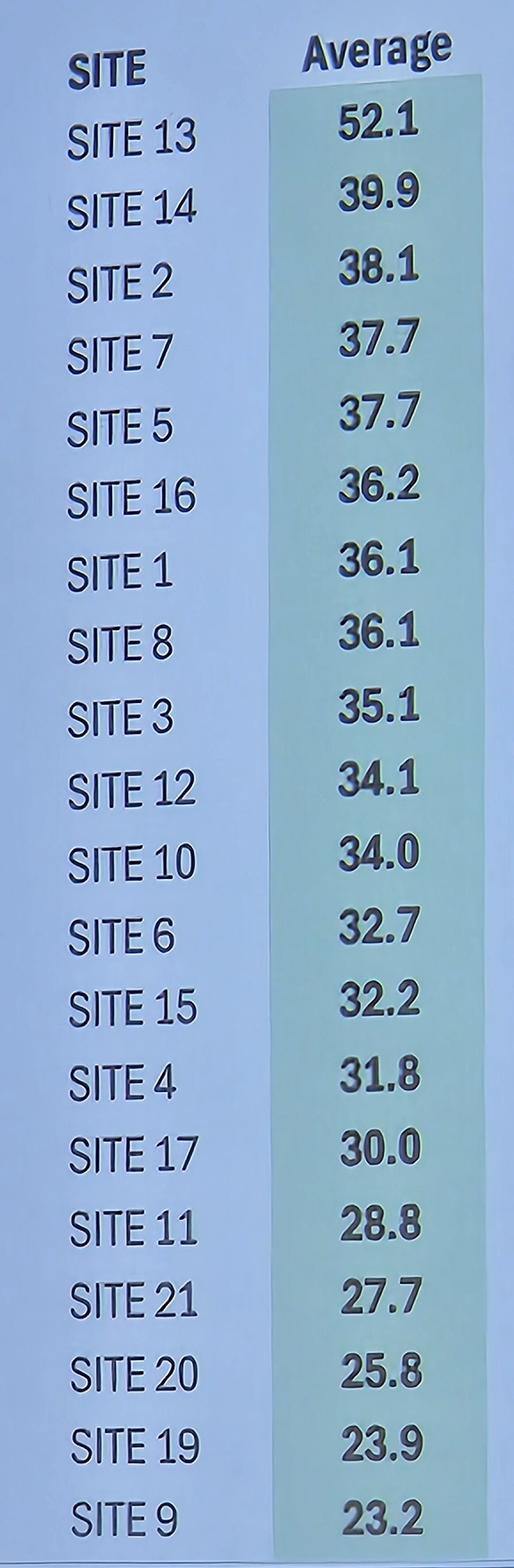
The following sites were under evaluation by the City of Lebanon Site Selection Committee as of May 31, 2026. Highlighted sites (green) are within or immediately adjacent to the city limits of Lebanon — the alternatives the petitioners are requesting the committee prioritize. All other sites are outside the city limits and are the subject of the public record statements on this site; Sites 1–7 form the primary rural residential corridor along Coles Ferry Pike, Mann Road, and Berea Church Road, with Sites 8–12, 18, and 19 sharing the same core concerns. The committee added sites 13A and 16–19 on June 2, 2026; Rev C of the public record statement acknowledges nineteen sites. Site 22 (Maple Hill Road, parcel 046 021.01) was added at the June 29, 2026 committee meeting.
Site qualification coloring current as of Selection Committee results on August 4, 2026.
Not eliminated, not fully within city limits Not eliminated, within city limits Undetermined Eliminated Sort by status
All sites with color are current candidates for the new wastewater treatment facility.
| Site | Rank * | Inside City Limits | Willing Seller † | Address | Acres | Property ID | Notes |
|---|---|---|---|---|---|---|---|
| 1 | 36.1 | 3230 Mann Road | 234 | Map 25 Parcel 41 | Acreage listed as 235 in property ID source. 3.2% in flood plain; single home and outbuildings on site; no gas or three-phase power (extension needed); narrow road, improvements likely; cut/fill balances; ~$8M conveyance. | ||
| 2 | 38.1 | Yes | 3965 Mann Road | 66 | Map 25 Parcel 33 | Eliminated August 4, 2026: combined committee ranking of 46 (lowest of the final four); removed by floor amendment citing excessive on-site grading to the property lines, no buffer, access challenges, and separation from existing city infrastructure. Public comment also raised ~2,700+ acres of adjacent property that could gain right-to-service rights under HB 2385/SB 2057 if this site were selected, and the absence of nearby three-phase power/gas. Same utility constraints as site 1 (no gas/three-phase; ~14,000 ft of new three-phase line needed per July 21 update); ~1,000 ft from main line, ~$1M conveyance (revised July 21; earlier estimate was ~$500K); 9.6% in flood plain (NW corner); at least one home and another structure on site; hill cut needed — engineer described it as the smallest of the final four, requiring the most grading; no geotechnical data yet, sinkhole potential flagged (July 21); Mann Road access likely needs significant county improvements (narrow, curved road). | |
| 3 | 35.1 | 800 Berea Church Road | 70 | Map 35 Parcel 12.13 | Steep hill, significant cut needed; ~800 ft from main line; 2% in flood plain (bottom of hill); no existing structures on site; gas and three-phase power available at Coles Ferry Pike (extension needed); ~$2M conveyance. | ||
| 4 | 31.8 | 755 Coles Ferry Pike | 49 | Map 35 Parcel 9.03 | Adjacent to site 3; smaller with less vegetative buffer; <100 ft from main line; 1.9% in flood plain; no existing structures on site; closer to Berea Church school; gas/three-phase from Coles Ferry Pike; combining with site 3 discussed; ~$500K conveyance. | ||
| 5 | 37.7 | 5335 Coles Ferry Pike | 187 | Map 35 Parcel 19.04 | Across from Berea Church Road and Friendship Christian School; considerably more residential than sites 1–4; ~250 ft from force main, both force mains adjacent; existing structures on site; water/gas/three-phase available; no flood plane. | ||
| 6 | 32.7 | 6390 Coles Ferry Pike | 223 | Map 35 Parcel 8 | Large tract west of Barton’s Creek; 4.8% in flood plain; ~3,300 ft from main line, pipe required from both force mains; water/gas/three-phase available; city need not acquire full parcel; ~$10M conveyance. | ||
| 7 | 37.7 | Yes | 208 Oriole Drive | 97 | Map 35 Parcel 27 | South of site 6; adequate room and buffer; house on property; flood plain %: May 27 transcript says 18.5%, June 2 transcript says none (discrepancy unresolved); ~$15.79M conveyance (revised July 21 by repurposing existing effluent force mains; original June 2 estimate was ~$28M); three-phase power, water, and gas already at the road; up to two pump stations (Summerset, Plantation South) could be eliminated; partially inside the Urban Growth Boundary (July 21 transcript, 42:39–42:57). | |
| 8 | 36.1 | 914 Maple Hill Road | 164 | Map 46 Parcel 21.02 | Subdivisions to W, E, and S; 41% in flood plain; one force main on site, ~4,250 ft to interconnect second force main; adequate room outside floodway; water/gas available; single-phase only (three-phase needed); narrow road, improvements expected. | ||
| 9 | 23.2 | 3370 Coles Ferry Pike | 105 | Map 45 Parcel 12 | ~71% in flood plain; site mostly floodway, assessed as not very usable; existing structures on site; fronts Coles Ferry Pike; line distance: May 27 says 2,800 ft, June 2 says ~7,100 ft (discrepancy — engineer flagged measurement ambiguity in May 27 meeting); three-phase electric/water/gas available; ~$8M conveyance. | ||
| 10 | 34.0 | 3345 Coles Ferry Pike | 93 | Map 45 Parcel 17 | No flood plane; northern boundary adjoins Wilson County landfill; water/gas at Coles Ferry Pike, three-phase available; ~$18.5M conveyance. | ||
| 11 | 28.8 | 3265 Coles Ferry Pike | 56 | Map 45 Parcel 18 | Adjacent to site 10; very limited vegetative buffer; water/gas/three-phase available; ~$18.5M conveyance. | ||
| 12 | 34.1 | 511 Walker Lane | 356 | Map 45 Parcel 36 | Close to Wilson County landfill; 8.9% in flood plain; facility sited near Hartman Drive to limit traffic impact; water/gas/three-phase available; ~$14M conveyance. | ||
| 13 | 52.1 | Yes | Yes | 510 Hartman Drive | 59 | Map 58 Parcel 28 Map 58 Parcel 15.39 Map 45 Parcel 57.00 |
Rockwood (existing industrial site); 99.8% in flood plain (45% floodway, 55% flood plain) — engineer described the rearranged layout's flood plain impingement as minor and mitigable (July 21); adjacent to both force mains; good road frontage, though access would require a new bridge across the creek; 100-ft gas easement limits buildable area; no Phase 1/2 environmental assessment completed; unknown fill bearing capacity on the Rockwood parcel; ~$9.85M conveyance (July 21). Site 13A (Hartman Drive, ~130 acres, Maps 58-028.00, 58-015.39, 45-057.00, 45-058.00 (Combined)) was originally listed separately as a three-parcel combination adjacent to this site, with a 60-ft stream buffer between them; consolidated here as the committee decided that these sites are only viable when combined. Parcel 13C (Map 45 Parcel 58.00, ~16 acres) removed from this site's parcel list July 22, 2026: its owner declined to discuss a sale per the mayor's July 21 report, and the engineer presented a rearranged layout without it (final clarifiers shifted east onto the Rockwood property). |
| 14 | 39.9 | Yes | 1310 Quarles Drive | 24 | Map 58G Group A Parcel 2 | Across Hartman Drive from existing plant; only 23.7 acres — full buildout doesn’t fit; no flood plain; active manufacturing on site (only US facility of its kind); inside industrial zoning; ~$500K conveyance. | |
| 15 | 32.2 | Yes | 1103 Baddour Drive | 47 | Map 58M Group B Parcel 33 | TRW site, city-owned; 46.4% in flood plain — full buildout doesn’t fit; would split treatment with existing plant (splitting sites 14+15 also discussed); three-phase/water/gas available; line distance: May 27 says 3,500 ft, June 2 says ~7,000 ft (discrepancy); ~$7M conveyance; significant environmental concerns, ongoing state brownfield remediation. | |
| 16 | 36.2 | Yes | 305–309 Hartmann Drive | 73.06 | Map 58 Parcel 24.03 | Adjacent to existing plant; owned by Cracker Barrel #1 (Johnston & Brooks subdivision); brownfield remediation by state of TN. | |
| 17 | 30.0 | Yes | 200 Carver Lane | 38.56 | Map 57 Parcel 63.02 | City of Lebanon property; existing utilities dept offices; 38.56 acres — below 60-acre minimum. | |
| 18 | — | Trice Road | 82 | Map 46 Parcel 8.00 Map 46 Parcel 21.02 |
56% flood-impacted; split parcel (~45 and ~37 acres); roadway improvements needed | ||
| 19 | 23.9 | Coles Ferry Pike | 43 | Map 35 Parcel 9.00 | Adjacent to sites 3, 4 & 6; same owner as site 4 (Jerry & Maureen Carney Byrd); 71.4% flood plane/floodway; deeded acreage 0, calculated 43 acres. | ||
| 20 | 25.8 | Barton's Creek | Screenshot | Corps of Engineers property (does not sell — lease only); adjacent to sites 1 and 2; currently managed by TWRA as a wildlife preserve; same access constraints as sites 1 & 2 (single-phase power, no gas, roadway improvements needed); flood plain present, leasing requires flood plain impact offset; excavation limited to ~4–5 ft due to groundwater influence from lake/river — above-ground structures would be 15–20 ft adjacent to neighbors; federal permitting/lease process expected to be lengthy (committee member cited 8+ years for a nearby Corps boat ramp). Site surfaced in a 1970s feasibility study. (Sources: engineer's presentation June 2, 2026 at 1:15:22; committee discussion June 15, 2026 at 1:46:19.) | |||
| 22 | — | Yes | Yes | Maple Hill Road | 150 | Map 46 Parcel 021.01 | Added at the June 29, 2026 committee meeting. Owned by Cedar Farm Owner LLC Etals Merchants and Dover, Valor Res New & Vakir Res New II. Previously misidentified as 409 Carver Ln; the Carver Ln reference in the June 29 transcript is a force main routing option described by engineer Steve Jones, not the site address. Parcel confirmed from motion language at 26:23 in the June 29 transcript. July 21 update: developer-provided due diligence reviewed by the engineer found a clean Phase 1 environmental assessment; a small family cemetery near a property line (requires a buffer and maintained access, not viewed as a negative); streams/wetlands confined to the north and south edges with minimal impact on the buildable area; rock typically within ~3 ft of the surface (typical for Wilson County, no bearing-capacity concern). Requires the most piping of the final four: ~20,000 ft, ~$24.9M conveyance (highest of the four); three-phase power ~1,500 ft south of the site; opens 605 acres of force-main-adjacent property and ~1,330 acres for gravity service, potentially eliminating up to eight pump stations. On a county road that may need improvements. |