Lebanon WWTP Site Selection — Public Record Archive | Return to main page
Prepared July 2, 2026 — Sources: June 2 and June 29, 2026 committee meeting transcripts; TN Property Viewer (tnmap.tn.gov)
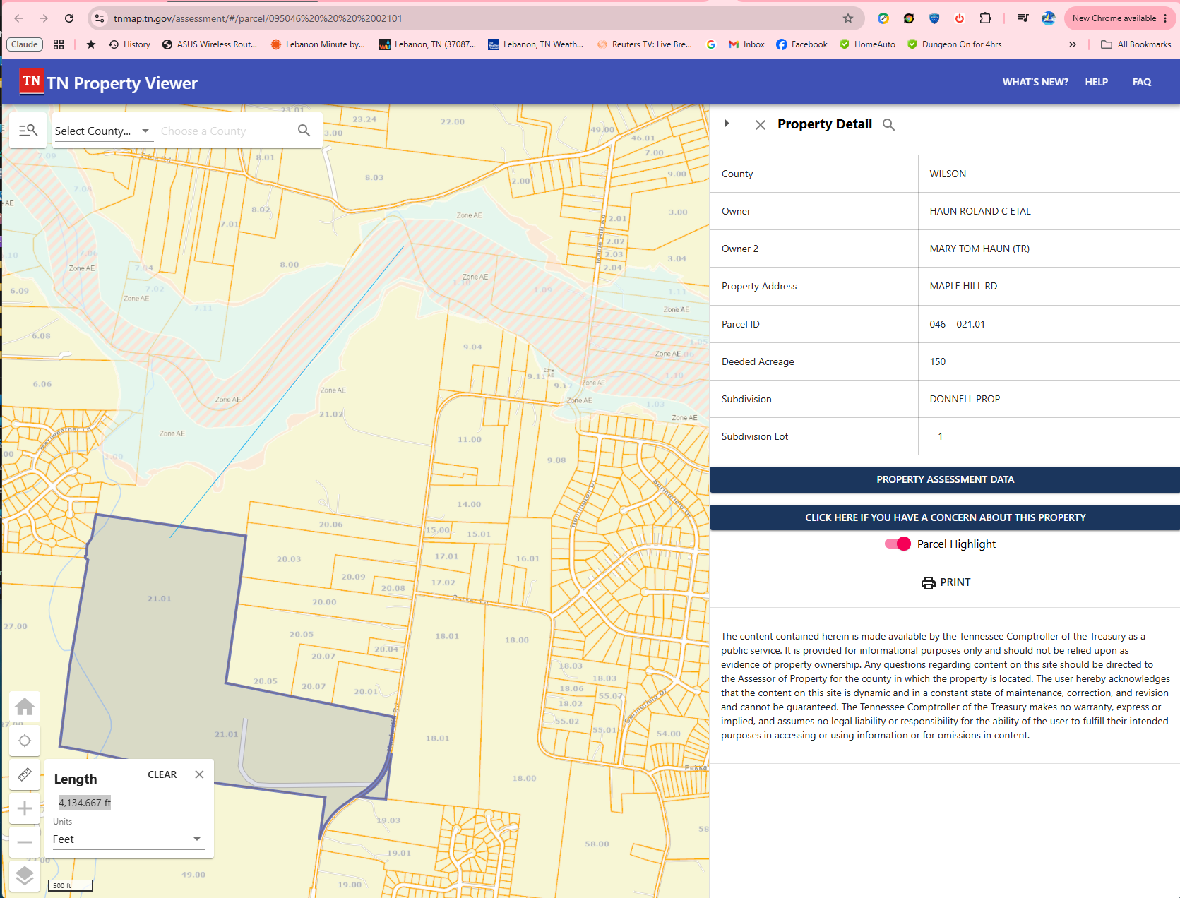
Engineer Steve Jones stated at the June 29 committee meeting that Site 22 (Maple Hill Road) would require approximately 25,000–30,000 feet of new conveyance pipe. A straight-line measurement using the Tennessee Property Viewer from the Site 22 parcel boundary to the nearest point on the existing force main — which runs through adjacent Site 8 on Maple Hill Road — measures 4,134.7 feet. Accounting for both an influent and effluent pipe run, total new pipe is approximately 8,300 feet: roughly one-third of Jones’s lower estimate and one-quarter of his upper estimate.
Site 22 (parcel 046 021.01, Maple Hill Road, 150 acres, inside city limits) was added to the shortlist at the June 29, 2026 committee meeting. When the committee asked the engineer to comment on Site 22’s infrastructure characteristics, Steve Jones addressed conveyance distance as the primary cost driver.
“There’s approximately 30,000 feet of line that would be required to convey flow to the property. So, assuming that you came down Trice Road and then came down that direction, potentially a little bit less if you came across through Carver and back down. So, you know, that might be reduced to 25 or so thousand feet required.”
Jones described a routing that runs from the existing force main via Trice Road, then south to the property — a circuitous overland route. He acknowledged a shorter path through Carver Lane would reduce the estimate to approximately 25,000 feet. Neither figure accounts for the existing force main that already runs through Site 8, which is directly adjacent to Site 22 on Maple Hill Road.
Jones himself confirmed the proximity at the same meeting (24:21–24:29):
“It is directly adjacent to the existing site 8. So, it has some of the same potential issues that we’ve discussed before with road access.”
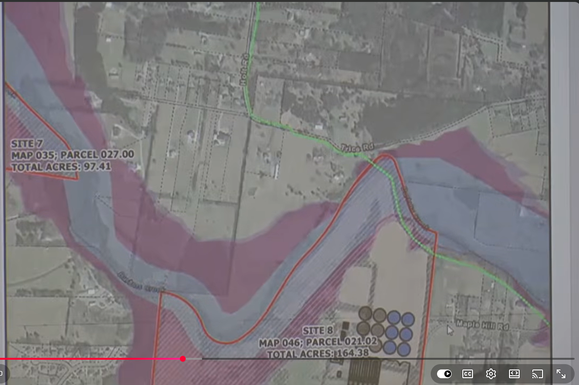
The force main serving the Maple Hill Road corridor is visible in the GIS data and runs through the Site 8 parcel (Map 55, Parcel 237.00, 97.41 acres), immediately north of Site 22. Figure 1 below shows the force main’s position relative to Site 8.
Using the Tennessee Property Viewer’s built-in measurement tool (tnmap.tn.gov), a straight-line distance was drawn from the Site 22 parcel boundary to the nearest accessible point on the existing force main running through Site 8. That measurement is shown in Figure 2.
| Source | Estimated distance | Basis |
|---|---|---|
| Steve Jones, June 29 committee meeting | ~25,000–30,000 ft | Routing via Trice Road (or Carver Lane); connection point not specified |
| TN Property Viewer measurement (straight-line) | 4,134.7 ft (one-way) ~8,300 ft (both pipe runs) |
Straight line from Site 22 boundary to nearest point on existing force main through Site 8; ×2 for influent and effluent pipe |
At the June 2, 2026 committee meeting, Jones described road conditions on Maple Hill Road during his Site 8 presentation (47:11–47:29):
“As far as the road is concerned, this is approximately a 24 foot wide road. It is striped, but it has limited shoulders. So, I would anticipate that there would be some improvements to the roadway along Maple Hill in order to make traffic for dump trucks a little better.”
At the June 29 meeting Jones stated this same road access concern carries over to Site 22 by virtue of its direct adjacency to Site 8. Because Maple Hill Road is a county-maintained road, any required road improvements would involve the county as well as the city, and those costs are not reflected in any site scoring to date.